Hometown Information Network > 岡山市東区における浸水被害の様子
岡山市東区における浸水被害の様子

Category Information
Hometown Information Network > 郷土情報ネットワーク > 10 岡山県(行政資料・岡山県のPRビデオなど) > 平成30年7月豪雨災害デジタルアーカイブ > 地区 > 岡山市 > 岡山市 東区
| Hometown Information Network > 郷土情報ネットワーク > 10 岡山県(行政資料・岡山県のPRビデオなど) > 平成30年7月豪雨災害デジタルアーカイブ > 地区 > 岡山市 > 岡山市 東区 |
Meta data
| Title | |
|---|---|
| Title | 岡山市東区における浸水被害の様子 (オカヤマシヒガシクニオケル シンスイヒガイノヨウス) |
| Kind of hometown information | |
| Kind of hometown information | IMAGE |
| Creator | |
| Creator | 小西 啓二 (コニシ ケイジ) |
| Those who open it to the public or groups of opening to the public | |
| Those who open it to the public or groups of opening to the public | 岡山県 危機管理課 (オカヤマケン キキカンリカ) |
| Outline of Hometown information | |
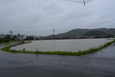
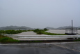
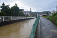
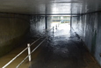
| Outline of Hometown information | 旭ヶ丘~平島における浸水被害の様子 |
| Era | |
| Era | 平成時代 |
| Location | |
| Location | 岡山県岡山市東区 |
| NDC classification | |
| NDC classification | 517:河海工学.河川工学 |
| Search keyword | |
|---|---|
| Search keyword | 災害 豪雨災害 |
| Reference source or quotation source(URL) | |
| Reference source or quotation source(URL) | |
| Age of object | |
| Age of object | 全年齢 |
| Language of hometown information | |
| Language of hometown information | jpn |
| Date of meta data making | |
| Date of meta data making | 2020-11-17 |
| Date of meta data opening to the public | |
| Date of meta data opening to the public | 2021-04-01 |
| Date of meta data update | |
| Date of meta data update | 2021-03-24 |
| URL on this page | |
|---|---|
| URL on this page | http://digioka.libnet.pref.okayama.jp/detail-en/id/kyo/M2021020614452211687 |