Hometown Information Network > 岡山市明細地図 明治44年(KM110/30)
岡山市明細地図 明治44年(KM110/30)
Category Information
| Hometown Information Network > 郷土情報ネットワーク > 11 岡山県立図書館 > 絵図・古地図 |
Meta data
| Title | |
|---|---|
| Title | 岡山市明細地図 明治44年(KM110/30) (オカヤマシメイサイチズ メイジ44ネン KM110/30) |
| Kind of hometown information | |
| Kind of hometown information | IMAGE |
| Creator | |
| Creator | 大真屋 美雄/編 (オオマヤヨシオ) |
| Those who open it to the public or groups of opening to the public | |
| Those who open it to the public or groups of opening to the public | 大久保翠琴堂 (オオクボスイキンドウ) |
| Outline of Hometown information | |
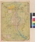
| Outline of Hometown information | 図1枚 55×40cm(折りたたみ19cm) View the next この地図は明治44年(1911)10月10日に大久保翠琴堂から発行されたものである。宇野線の線路が描かれているが、宇野線は明治43年(1910)6月12日に開通した。また四国連絡航路(宇野〜高松)も開設された。西大寺町に二十二銀行がある。この銀行は株式会社で頭取は安田善八郎(*1)、監督は安田善三郎(*2)であった。したがって二十二銀行は安田系列銀行だといえる。専務は香川真一、取締役は杉山岩三郎等が名を連ねた。明治44年の出来事を少し紹介する。地図中の富田町のところに武徳殿がある。武徳殿は武道普及の中心道場であった。2月に完成した。西中山下に女子師範学校がある。女子師範学校は岡山女子高等学校から分離して4月1日に西中山下に移転した。明治44年の岡山市は現在の市域よりもはるかに狭かった。註(*1)安田善次郎の妹清子の長女の婿養子(*2)安田善次郎の二女暉子の婿(善次郎養嗣子) Close the next |
| Era | |
| Era | 1911 |
| Location | |
| Location | 岡山県岡山市 |
| NDC classification | |
| NDC classification | 291.75:岡山県 |
| Search keyword | |
|---|---|
| Search keyword | 県地図 |
| Age of object | |
| Age of object | 全年齢, 高校生, 中学生, 小学生(高学年), 小学生(低学年以下) |
| Language of hometown information | |
| Language of hometown information | jpn |
| Date of meta data opening to the public | |
| Date of meta data opening to the public | 2011-02-28 |
| Date of meta data update | |
| Date of meta data update | 2016-06-29 |
| URL on this page | |
|---|---|
| URL on this page | http://digioka.libnet.pref.okayama.jp/detail-en/id/kyo/M2004093016425442323 |